State Mapping Advisory Committee (SMAC)
March 14, 2002 - Meeting Notes
Location
Nevada Geographic Information Society Conference 2002
Held at the Orleans Hotel & Casino Conference Facility
4500 West Tropicana Avenue
Las Vegas, NV 89103
For further Information please contact Ron Hess
Nevada Bureau of Mines and Geology
(775)784-6691 Ext. 121 or Email: rhess@unr.edu
5:30 PM: OPENING REMARKS and Welcome by Ron Hess, Committee Executive Secretary
The Governor of Nevada established the State Mapping Advisory Committee (SMAC) in 1983 to advise the U.S. Geological Survey (USGS) on state priorities for map products and to inform map users about the status of mapping programs and the availability of map products in Nevada.
OLD and NEW BUSINESS
Report on U.S. Geological Survey’s National Mapping Discipline projects in Nevada, by Tom Sturm, USGS.
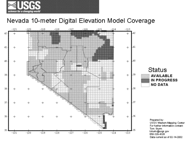
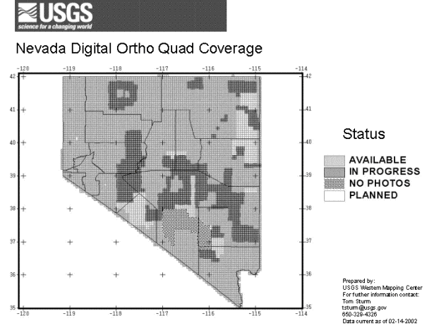
Tom reported that the Bureau of Land Management has agreed to provide funding to complete first time Digital Orthophoto Quadrangle (DOQ) coverage of Northern and Central Nevada by the end of next year. The Southern Nevada Water Authority will fund completion of some DOQs in Northern Clark County and Southern Lincoln County. After these projects are completed the only area in Nevada without DOQ coverage will be over the Nellis Air Force Range. Conversion of existing 30 meter Digital Elevation Models (DEM) to 10 meter DEMs will be the next priority in Nevada. Currently, 30 DEM coverage for Nevada is complete and most of Northern and Central Nevada have 10 meter DEM coverage. The National Elevation Database (NED) currently distributes this data digitally in custom blocks at 30 meter resolution but in the near future customers will also be able to obtain 10 meter NED data where it is available. Status maps for DOQs and 10 meter DEMs are attached. A new Web based seamless map data distribution tool is online at http://edcnts14.cr.usgs.gov/website/store/viewer.htm .
The Lake Tahoe Area has been selected as a pilot project for the National Map Program. The national map is an effort by the USGS to obtain, produce, and distribute updated digital map data on a nation-wide basis. Lake Tahoe has been selected as a test site for implementation of the National Map model. Updated road, hydrology, DEM, and DOQ data will be obtained for Lake Tahoe and made available on-line as part of the National Map model. The new DOQs for the Tahoe project will be based on 1998 NAPP photography over California and 1999 NAPP photography over Nevada. This program is developing as it moves forward. Various questions and ideas as to the data format, content, and web availability are still being discussed and/or developed. The Web address for the Lake Tahoe clearing house site is http://tahoe.usgs.gov/ .
Mark O’Brien reported on the BLM DOI high priority mapping requirements and BLM funding of some Nevada DOQs as discussed above. After completion of first time coverage of DOQs, emphasis will be placed on conversion of 30 meter DEM data to 10 meter DEMs. Following completion of 10 meter DEMs emphasis will be placed on completing a high resolution hydro coverage as part of the National Hydrography Dataset (NHD). Currently, the NHD only contains 100k hydro data for Nevada developed from the 1:100,000 scale digital line graphs (DLGs). More information on the NHD can be found on the Web at http://nhd.usgs.gov/ .
Ron Hess reported that over the last several years the State Mapping Advisory Committee’s 1st priority has been completion of first time DOQ coverage of Nevada with the 2nd priority being acquisition of DEM data.
Mark also reported that some updates have been made to the BLM Geographic Coordinate Database (GCDB) since the last SMAC meeting but it still is not complete. It is a work in progress.
Mike Turner and Eric Warmath from Nevada Department of Transportation (NDOT) reported that they are currently mosaicing all of the existing DOQs for Nevada into 7.5 minute and 30 minute quadrangles using MrSid software. When completed, copies will be given to the Keck Web site ( https://keck-nbmg.opendata.arcgis.com// ) for free public distribution. NDOT is currently using GPS to obtain a new digital major roads coverage for Nevada. In the next few months, NDOT will release an updated version of the Nevada State and County boundaries map which will include all legislative boundary changes to present.
Report of the SMAC Geologic Mapping Subcommittee, Chris Henry, Nevada Bureau of Mines and Geology (NBMG), chairman: report presented by Ron Hess. NBMG, through the STATEMAP program, continues geologic mapping in three priority areas set by the Subcommittee: Las Vegas (including Pahrump), Reno-Carson City, and the Humboldt Basin. Additionally, fully attributed GIS versions are being developed of previous STATEMAP and other existing maps. Mapping beginning May 1, 2001 consisted of 3 quadrangles in the Las Vegas project, 4 in the Reno project, and 10 GIS maps, including the 1:100,000 Carson City map. Mapping to begin May 1, 2002 consists of parts of 6 maps in the Las Vegas project, 1 in the Reno project, and 1 in the Humboldt Basin, as well as 11 GIS maps. Four maps were published in 2001, and several are in final preparation for publication.
Ron Hess reported that there were approximately 60 attendees at the NASA/WGA sponsored Remote Sensing and Image Processing Workshop for Nevada State and Local Agencies held in Reno on May 17, 2001. The workshop was jointly sponsored by the Western Governors’ Association, NASA, and the Nevada Bureau of Mines and Geology. The purpose of the workshop was to help develop remote sensing knowledge and abilities in State and Local agencies. As part of the workshop, some Landsat and Spot data sets were purchased and placed on the Keck Web site ( https://keck-nbmg.opendata.arcgis.com// ). An on-line NASA Remote Sensing Tutorial and some of the PowerPoint presentations given at the workshop are located on the Nevada Bureau of Mines and Geology FTP site at ftp://ftp.nbmg.unr.edu/NBMG/NASA_WORKSHOP/START_HERE.html .
Ron Hess discussed the FGDC I-Team initiative. The I-Team Geospatial Information Initiative (I-Team Initiative) is a joint project of the Federal Geographic Data Committee (FGDC), Federal Office of Management and Budget (OMB), the Council for Excellence in Government, Urban Logic, NSGIC, NACO, and other strategic partners. Part of the next phase of efforts to build a National Spatial Data Infrastructure (NSDI), the I-Team Initiative addresses the institutional and financial barriers to development of the NSDI. It aims to offer a coherent set of institutional and financial incentives to make it easier for all levels of government and the private sector to collaborate in the building of the next generation of framework data. By aligning participant needs and resources, the I-Team Initiative will help all levels of government and the private sector to save money, migrate from existing legacy systems, make better use of existing resources, and develop the business case for additional public and private resources.
I-Teams are a Self-Organizing Information Consortia. Instead of top-down mandates, the I-Team Initiative relies on locally formed, interdependent partnerships of federal, state, local, and tribal authorities, academia, and the private sector to implement state and regional portions of the NSDI in accordance with national interoperability specifications and data standards as part of their ordinary business processes. The I-Teams are voluntary, open, flexible and adaptive collaborations for shared capital planning, building, using and financing spatial data. They optimize and align the interdependencies allowing institutions and citizens to rely on and share quality data from other trusted sources. Existing organizations and groups can develop I-Team goals and plans to advance the development of the NSDI.
Several other States are developing I-Teams and their associated business plans to assist in pursuit of potential Federal or State funding sources. Some focus on framework data layers while others include such layers as soils, geology, utilities, etc. Utah was identified as being one of the first States to develop an I-Team. GISMO in Clark County already functions as an I-Team but does not see any benefit to go to an extra effort just to be considered an FGDC defined I-Team. Mike Turner and Eric Warmath will explore the possibility of developing an I-Team based on transportation and associated layers such as DOQs. It could include NDOT, county and local transportation agencies, Federal DOT, USGS, BLM, USFS, NBMG, and other interested parties. If NDOT is interested in pursuing formulation of an I-Team or developing one through SMAC we will hold another SMAC meeting to develop the particulars. If after some thought or in discussions with others, attendees come up with ideas or questions about the I-Team initiative, they were encouraged to contact Ron Hess. Additional information on the FGDC I-Team initiative is available on the Web at http://fgdc.gov/I-Team/ .
Eric Warmath requested that agencies move to the North American Datum of 1983 (NAD83) for digital data exchange purposes. NAD83 has been adopted by Nevada since the mid-80s as a control standard. But many agencies still maintain their data collections in the North American Datum 1927 (NAD27). This adds extra steps and sometimes confusion when exchanging data. The Nevada Bureau of Mines and Geology still uses NAD27 because they publish on paper base maps that are in that projection. All of the 1900+ published USGS topographic maps in Nevada are in NAD27. All of the Nevada 1:24,000 scale topographic maps in NAD27 are freely available for download from the Keck Web site ( https://keck-nbmg.opendata.arcgis.com// ). Differences between NAD27 and NAD83 UTM coordinates in Nevada range between 100 and 300 meters. Further complicating the exchange of data is the use of localized ellipsoid correction or modification factors that are being used by some agencies such as Washoe County.
Discussion of State and Local Agency Mapping Requirements for 2002-2003:
General comments throughout the meeting focused on completion of DOQs, DEMs, Hydro data, and digital roads data for Nevada. Attendees were requested to contact Ron Hess or Tom Sturm if they or their agency has or develops a framework mapping requirement that might be addressed by working with or through the USGS and/or BLM.
7:30 PM: MEETING ADJOURNED
If you have questions please contact Ron Hess, Executive Secretary, Nevada State Mapping Advisory Committee at (775) 784-6691 x 121 or Email rhess@unr.edu.
State Mapping Advisory Committee Web Page
http://www.nbmg.unr.edu/smac/smac.htm
Virtual Clearinghouse of Nevada Geographic Information Web Page
http://www.nbmg.unr.edu/geoinfo/geoinfo.htm
Meeting Attendees
Ron Hess Nevada Bureau of Mines and Geology
Tim Mueller Nevada Department of Transportation / NV Geographic Information Society
Jeff Schmitz Nevada Department of Transportation
Michael Turner Nevada Department of Transportation
Lisa Smith Biologic Resources Research Center
Scott Royal
Clint Celia
Lindy Gash Nevada State Lands
Kobe Hackihs Washoe County
Art Ehrenberg Southern Nevada Water Authority
Michael Bish Nevada Department of Transportation
Donald Harper U.S. Geologic Survey - Water Resources Division
Natalie Cutsforth Pixxures
Jaymes Pardue Emerge
Richard Johnson Brown & Caldwell
Judy Althoff Washoe County Regional Transportation Commission
Rick Free Nevada Department of Transportation
Tom Strum U.S. Geologic Survey - National Mapping Discipline
Eric Warmath Nevada Department of Transportation
M.H. Dillon Nevada Division of Water Resources
Jeff Stump Clark County Geographic Information Systems Management Office
Mark O’Brien Bureau of Land Management