
Monte Cristo Range Earthquake - May 15, 2020, 4:03 am PDT
The below summary was prepared during the days and weeks following the May 15, 2020 Monte Cristo Range earthquake. However, a new NBMG publication (Map 190) is now available, which includes a rupture map (2 sheets), report, ArcGIS Map package, and a Google Earth KMZ. These can be downloaded from the Monte Cristo Range Earthquake Data Page. A full GIS data package with the map documents, shapefiles, metadata and other information is also available through the NBMG shopping cart.
******
At 4:03 am local time (PDT) on May 15, 2020, a magnitude (M) 6.5 earthquake occurred approximately 56 miles (90 km) west of Tonopah, Nevada. Shaking was felt across a large area (as far away as San Francisco and Salt Lake City), and over 22,000 felt reports were submitted to the U.S. Geological Survey following the earthquake.
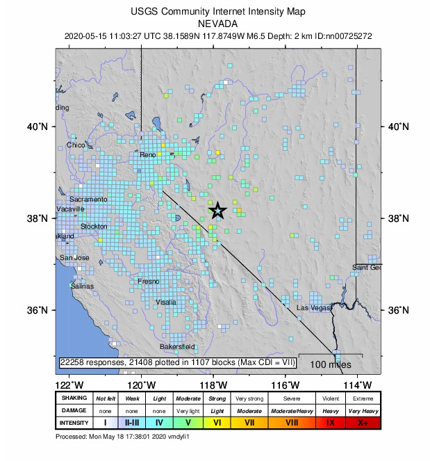
Image: U.S. Geological Survey map as of May 18, 2020 showing distribution of felt reports.
Strong ground shaking, oscillation of seismic waves in Columbus Salt Marsh basin, and possibly liquefaction during the earthquake caused differential ground settling of distal alluvial-fan and lacustrine deposits. This settling was immediately recognized by several zones of cracking across Highway 95, but no injuries or major damage were reported.
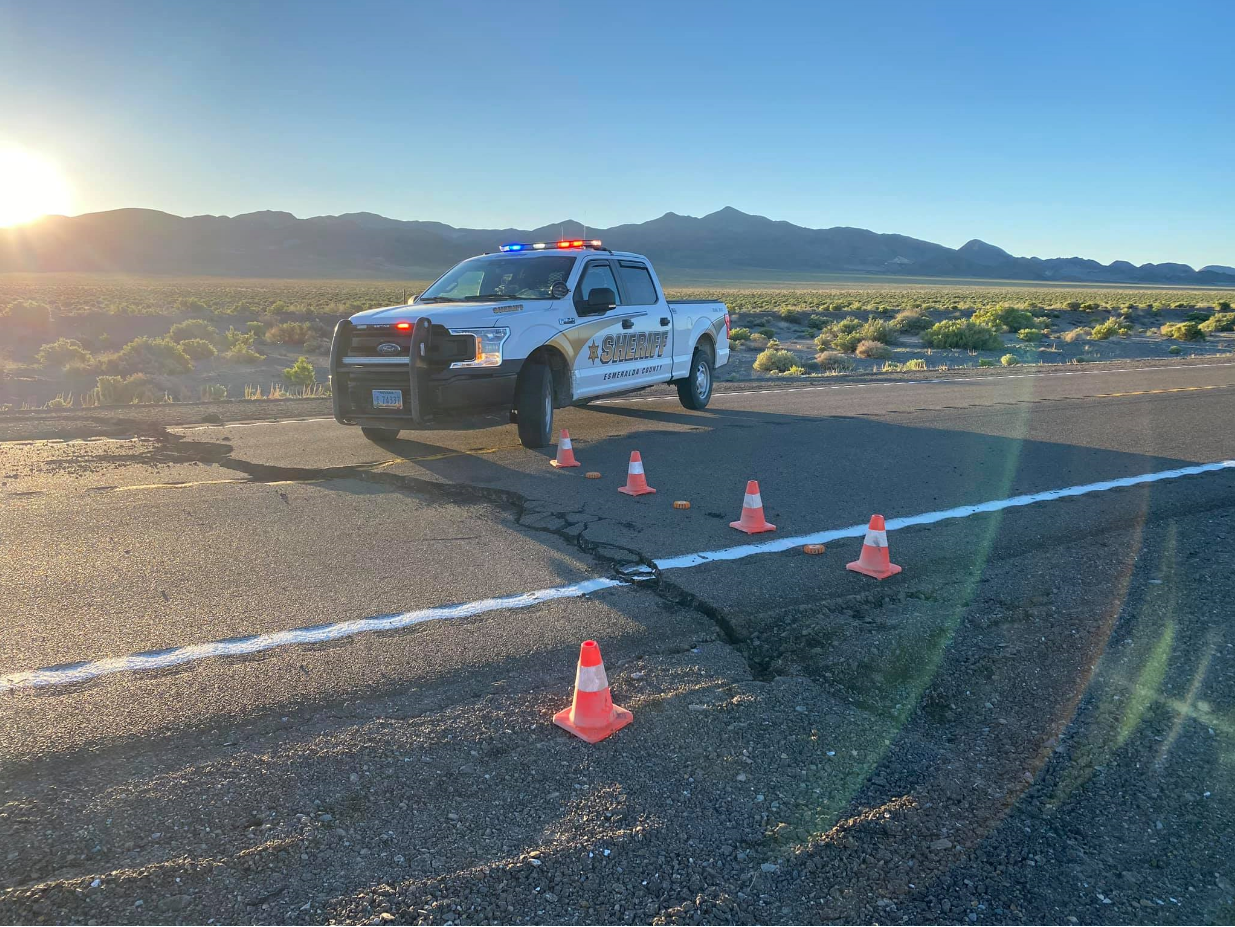
Image: Esmeralda County Sheriff’s Office photo of cracks across Highway 95.
The earthquake occurred in the Walker Lane seismic belt that extends along the eastern side of the Sierra Nevada and accommodates about 10–25% of the Pacific/North American plate boundary motion. The epicenter was located in an area known as the Mina Deflection, a series of east-west striking left-lateral strike-slip faults that act to connect sets of northwest-striking right-lateral faults to the northeast and southwest. Inspection of the seismicity indicates that the rupture occurred on an east-west striking plane with a left-lateral sense of motion. The rupture extends across the Monte Cristo Range and is generally spatially coincident with faults previously mapped in bedrock and along strike of the projection of the Quaternary-active Candelaria fault.
The Nevada Bureau of Mines and Geology (NBMG) quickly mobilized field teams after the mainshock and is currently working to characterize any surface ruptures, displacements, and other field observations in cooperation with the Nevada Seismological Laboratory, U.S. Geological Survey, and California Geological Survey.
Initial field observations suggested that the main left-lateral rupture was blind (did not reach the surface) and that deformation was primarily expressed as zones of generally north-striking fracture sets (centimeter-scale openings). Other secondary effects such as distributed rockfalls and small landslides along wash margins were widely observed. In the days after the event, careful inspection by field crews in the area north of the subsurface seismicity revealed the presence of a nearly continuous ~10-km-long surface rupture extending east of the mapped trace of the Candelaria fault. The rupture included left-lateral displacements on the order of 5-15 cm on northeast-striking faults and normal and purely extensional displacements on north-striking faults (~5-10 cm). The northeast-striking faults exhibit classic right-stepping traces and connecting moletracks similar to those observed in the 2019 M6.4 Ridgecrest earthquake. Left-stepping fracture patterns on north-striking fault planes are suggestive of right-lateral slip, although individual offsets were ambiguous. Subsequent to the initial field investigation, NBMG released a map of the rupture trace and associated field observations (Dee et al., 2021).
The Nevada Geodetic Laboratory (NGL) at NBMG/UNR is actively measuring ongoing deformation.
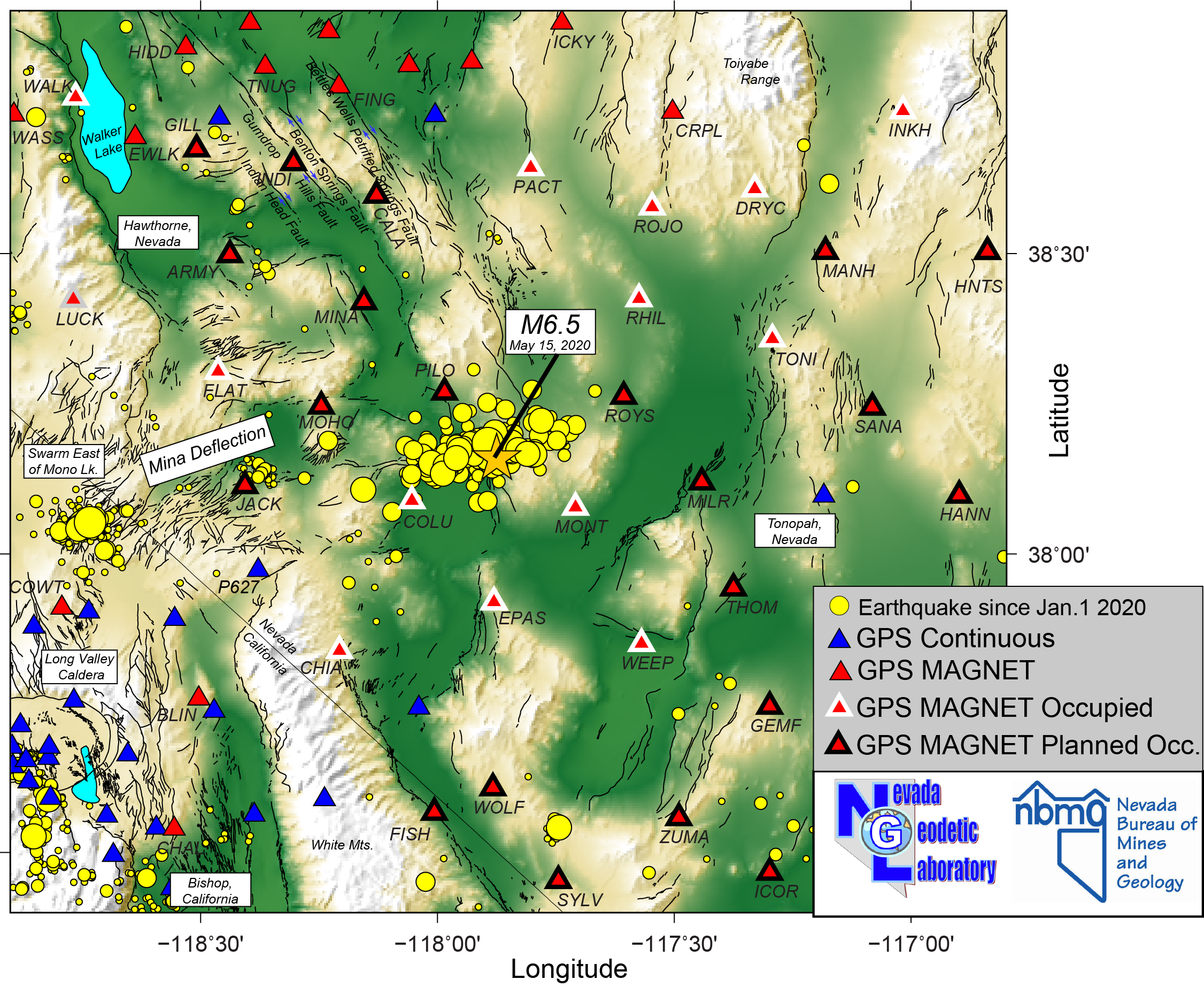
Image: NGL map showing locations of GPS stations and seismicity since January 1, 2020. The May 15, 2020 Monte Cristo Range M6.5 earthquake is shown with a star. Legend indicates which GPS stations in the MAGNET network (http://geodesy.unr.edu/magnet.php) were in place at time of the event, and which stations NGL plans to occupy for the project. Both of those sets of stations will be visited multiple times to constrain coseismic offset, potential postseismic displacement, and establish monitoring in the event of further earthquake events. Selected place names and MAGNET station names are annotated. The aftershocks of the M6.5 indicate that it was likely a left-lateral event whose slip plane can be extrapolated WSW to intersect the earthquake swarm east of Mono Lake that has been ongoing for several weeks. The aftershocks also lie along the southern extrapolation of the Benton Springs, Petrified Springs, and Gumdrop Hills right-lateral faults that accommodate northwest-southeast Walker Lane shear deformation. The Mina deflection is a zone with left-lateral faulting similar to the strike described by the cloud of aftershocks.
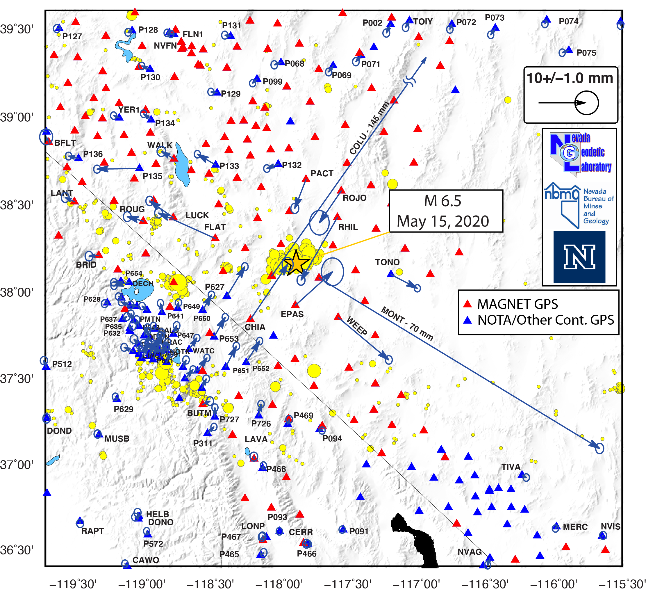
NGL has posted updated results from the Monte Cristo Range earthquake on their website, which are also included below. The latest data help 1) fill in the displacement pattern with more vectors, and 2) provide further evidence for left-lateral slip, in agreement with InSAR, seismicity, and the surface rupture observations, and 3) provide a preliminary offset table that folks can use for modeling (also available at link below).
From the NGL website (6/2/20):
"Over the past week data collection on the Monte Cristo Range earthquake has continued. We now have coseismic offsets on 24 MAGNET stations, 15 of which are recording signficant coseismic displacement. Stations in each of the four quadrants of the displacement field have returned data, revealing the systematic horizontal NW-SE extension, NE-SW contraction, characteristic of a strike slip earthquake. An updated offset map and table are provided below. The largest offset so far is at station COLU, on the west side of the Columbia Salt Marsh, which has 145 mm displacement to the northeast. These offsets and some preliminary modeling are now sufficient to favor slip on a left lateral plane striking 78 degrees clockwise from north, similar to what are indicated by InSAR, aftershock, and surface rupture data."
A table of preliminary coseismic offsets is available for download here.
The Nevada Seismological Laboratory at UNR is also deploying additional temporary seismometers to the area to continue to monitor the increased seismicity in the area.
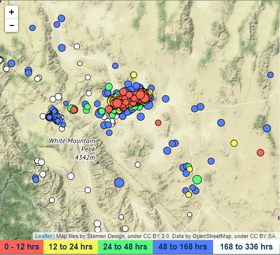
Image: Nevada Seismological Laboratory map as of May 18, 2020 showing
concentrated seismicity in the region after the M6.5 mainshock.
Please see the USGS event page for additional information. NBMG will also share information to this page as field observations and data are synthesized.
Digital datasets from the 2020 M6.5 Monte Cristo Range earthquake, Nevada
Additional resources:
U.S. Geological Survey event page
Maps of epicenter, shaking, felt reports and other scientific information specific to the event
https://earthquake.usgs.gov/earthquakes/eventpage/nn00725272/executive
Nevada Seismological Laboratory
Nevada Earthquake Catalog, press releases, and other related information
http://www.seismo.unr.edu/
Nevada Geodetic Laboratory
Maps and data associated with ongoing deformation of the area
http://geodesy.unr.edu/
Other links:
Monte Cristo Earthquake fault still active with 6,500 aftershocks
Finding Faults: How the burgeoning Walker Lane may split the American West
revised 6/2/2021 9:15 AM
 Home
Home