
Cinder Cone at Easy Chair Crater
Nye County, Nevada
GPS Coordinates: N38°26.290', W116°02.209' (WGS 84)
LOCATION: Along a dirt road south of U.S. Highway 6 between Tonopah and Ely.
WAYPOINTS: N38°28.720', W116°03.299': on the south side of the U.S. Highway 6, where it
intersects with the road to Lunar Crater.
N38°26.419', W116°03.481': where a road comes in from the left; turn left and drive southeast
along this road.
This Quaternary (less than 1.8 million years old) volcano is part of the Lunar Crater volcanic field.
Lunar Crater, a few kilometers to the south, is a maar, a type of volcano formed when magma approaching the surface from deep within the Earth violently boils the groundwater and tosses volcanic bombs (pieces of lava) onto the surface, often leaving a circular hole that later fills with a lake (if there is lots of water). At Lunar Crater, the ground water is too deep below the surface for a lake to form. Easy Chair Crater is a different type of volcano – a cinder cone. Cinder (also called scoria) is a volcanic rock with numerous holes formed by gas escaping from the cooling and crystallizing lava. This particular cinder cone has lots of volcanic bombs and a nice variety of crystals that formed from cooling magma deep within the Earth. The rock is termed a basalt, based on its mineralogy (dominantly plagioclase, clinopyroxene, and olivine) and chemistry (more magnesium, calcium, and iron and less silica, potassium, and sodium than other common igneous rocks).
Large crystals can be found either embedded in the volcanic bombs or as separate crystals. They include olivine (and the gem variety peridote), clinopyroxene, hornblende, plagioclase, anorthoclase, and magnetite. Some crystals are several centimeters long.
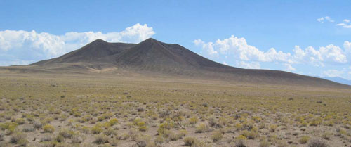
Figure 1. Easy Chair Crater viewed from the west.
Minerals that can easily be identified in this area (mostly as crystals a few millimeters in size):
• Plagioclase (a type of feldspar), a solid solution of dominantly CaAl2Si2O8 and NaAlSi308 – clear
to milky white, with cleavage and tiny lamellae from crystal twins.
• Hornblende-Kaersutite, a complex amphibole solid solution described chemically as
(Ca,Na,K)2-3(Mg,Fe,Mn)3-4(Al,Fe)2-1(Si,Al)8O22(O,OH,F)2 and NaCa2(Mg,Fe)4Ti (Si6Al2)8O22(O,OH,F)2– generally black prisms with two
directions of cleavage at 60° and 120°.
• Clinopyroxene, solid solution of dominantly MgSiO3, CaSiO3, and FeSiO3 –
generally black (sometimes dark green) prisms with two directions of cleavage at 90° but
also without visible cleavage and glassy, resembling obsidian.
• Olivine, a solid solution of dominantly Mg2SiO4 and Fe2SiO4 – olive or pale green, glassy.
• Magnetite, a solid solution of dominantly Fe3O4 and Fe2TiO4 – easily attracted to a magnet,
particularly if you put the magnet into the loose material eroded from the volcanic rocks.
Easy Chair Crater appears to have developed on the edge of an earlier cinder cone that appears to
have been centered a bit further to the north.
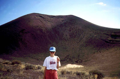
Figure 2. Easy Chair Crater has the form of an easy chair, with a high back and
sloping sides for arm rests. The girl in the photograph is holding a four-centimeter
-long clinopyroxene crystal.
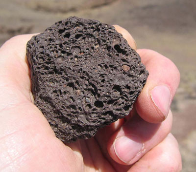
Figure 3. Geologists have figured out that gas bubbles in magma (composed mostly of
CO2 and
H2O) create the holes in scoria. Scoria is also called cinder. It is used in
gas-fired barbeque grills
in place of charcoal briquettes. It is also used as aggregate
in road construction and as a
decorative, architectural aggregate. Crystals normally
do not contain large holes, but some of the
crystals of clinopyroxene and plagioclase
and, less commonly, hornblende and olivine at Easy
Chair Crater contain holes.
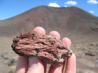
Figure 4. Volcanic bombs at Easy Chair Crater range from a few centimeters to more
than
one meter long.
OBSERVATION: Geologists have noted that cinder cones commonly have rims that are not even in height, but one side tends to build up more than another, either because of prevailing wind directions (blowing the bombs and cinders down wind) or because of the dynamics of the eruption (erupting in a particular direction or erupting from an off-centered vent).
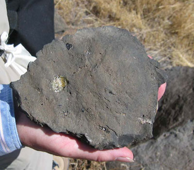
Figure 5. Crystals (here olive-green olivine and black to dark-green clinopyroxene)
occur in the lava bombs.
QUESTION: Which side of the rim (N, NE, E, SE, S, SW, W, NW) of volcano is highest in elevation?
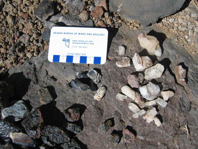
Figure 6. A collection of feldspar (presumably mostly plagioclase), clinopyroxene,
hornblende, and olivine crystals found while hiking into the center of the crater.
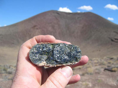
Figure 7. Exceptionally large crystal of glassy-appearing clinopyroxene.
References:
Wood and Kienle, 1990, Volcanoes of North America: United States and Canada: Cambridge
University Press, 354 p., p.256-262.
http://vulcan.wr.usgs.gov/Volcanoes/Nevada/description_nevada_volcanics.html#lunar_crater
Kleinhampl, F.J., and Ziony, J.I., 1985, Geology of northern Nye County, Nevada: Nevada Bureau
of Mines and Geology Bulletin 99A, 171 p., with maps at 1:250,000 scale.
SPECIAL NOTES ABOUT ACCESS AT THIS SITE
Hiking in the volcano can involve some steep, rocky and loose ground. Wear sturdy hiking boots. It
is also advisable to wear gloves.
CAUTION IN USING GPS UNITS AND TOPOGRAPHIC MAPS
(Note that GPS coordinates are relative to a particular datum used to describe the nearly spherical
shape of the Earth’s surface. Most topographic maps published by the U.S. Geological Survey use
the North American Datum of 1927 (NAD 27), but most GPS units are set for either the North
American Datum of 1983 (NAD 83) or the World Geodetic System of 1984 (WGS 84). NAD 83 and
WGS 84 give nearly identical locations with hand-held GPS instruments, but NAD 27 can be off
considerably. In this part of Nevada, there is little change in latitude between the 1927 and 1983
data, but for longitude the datum of 1983 is shifted relative to the datum of 1927, such that, if you
use your GPS unit to measure a location using WGS 84, the point will plot on the U.S. Geological
Survey topographic map approximately 100 meters farther east than its true location on the map. If
your GPS unit is set to NAD 27, you need to look for the WGS 84 waypoint approximately 100
meters farther east from your location.)
BASIC VISITOR-USE AND PUBLIC SAFETY INFORMATION FOR PUBLIC LANDS IN NEVADA:
All visitors need to plan ahead and prepare for outings in Nevada’s public lands by:
• Knowing the regulations and special concerns for the area you are planning to visit (obeying
laws that prohibit collection or destruction of artifacts)
• Carrying a map and a GPS unit and/or compass (Maps are available for purchase at all BLM
offices and from the Nevada Bureau of Mines and Geology, www.nbmg.unr.edu.)
• Staying on existing roads and trails
• Staying away from all mine shafts and adits
• Planning for extreme weather, hazards, and emergencies
• Carrying a full-size spare tire, extra food, water, and warm clothing
• Being aware that cell phones DO NOT usually work in the rural areas away from the major
highways
• Leaving your travel plans with a responsible party, including the date and time of your
return
• Linking to “Tread Lightly and Leave No Trace” websites (www.treadlightly.org and www.lnt.org).
Please see www.nbmg.unr.edu/ScienceEducation/EarthCaches/EarthCaches.html for more information about this and other Nevada
EarthCache and GeoCache sites of geologic interest. Thank you.
Contributed by J.G. Price and E.M. Price.
 Home
Home