
“Nice” (gneiss) Rocks at Island Lake on the side of Lamoille
Canyon in the Ruby Mountains
Elko County, Nevada
GPS Coordinates: N40°36.934', W115°22.791' (WGS 84)
LOCATION: Island Lake is located at the end of two-mile (3.2-km) trail that climbs gently, with
nine switchbacks, approximately 910 feet (280 meters) in elevation from the parking lot at the
end of the Lamoille Canyon Road. The parking lot is 12 miles (19 km) from State Route 227 and
approximately 31 miles (50 km) driving distance from Elko. If driving from Elko, turn south (right)
off State Route 227 onto the Lamoille Canyon Road before you get to the town of Lamoille, which
is 0.6 mile (1 km) farther east.
WAYPOINTS: N40°36.338', W115°22.543': trailhead on the west side of the road, at the north
end of the parking
lot.
N40°36.742', 15°22.516': first of nine switchbacks.
N40°36.698', W115°22.542': second switchback.
N40°36.997', W115°22.617': wooden bridge.
N40°37.015', W115°22.648': sixth switchback.
GEOLOGY
The Ruby Mountains and the East Humboldt Range to the northeast are part of a metamorphic core complex – a group of metamorphic and igneous rocks that were once buried deep within the Earth’s crust but are now exposed at the surface by a process of uplift and crustal extension. Keith Howard, a U.S. Geological Survey geologist who has mapped the rocks in this area in detail, correlated the metamorphic rocks exposed along the hike to Island Lake with sedimentary rocks of Ordovician and Cambrian age (approximately 540 to 443 million years old) found elsewhere in Nevada. The original sedimentary rocks (limestone, dolomite, and shale) have been metamorphosed to gneiss
(pronounced “nice”) and marble and have been intruded by igneous rocks (granite and pegmatite).
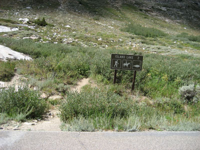
Figure 1a. Sign marking the trailhead for Island Lake. Watch for horses, and get
a license if you
want to try your luck fishing from the lake.
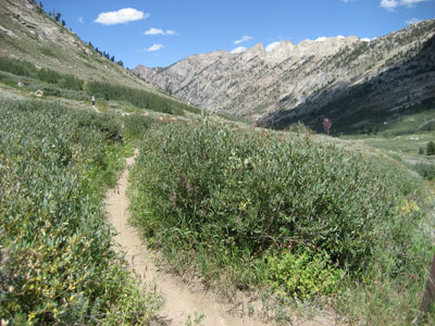
Figure 1b. View up the trail (to the north) from the trailhead (N40°36.338', W115°22.543').
The Ushaped
profile of Lamoille Canyon is characteristic of valleys carved by glaciers. The
profile of
valleys carved by streams are typically V-shaped.
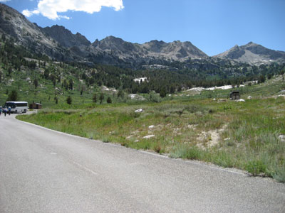
Figure 1c. View to the south (toward the parking lot) from the trailhead. The narrow
mountain crest
is an arête, formed by Pleistocene glaciers that carved into the
mountain from both sides of the ridge.
The rocks were buried deep in the Earth’s crust (probably at least 22 miles or 35 kilometers), in part by younger sedimentary rocks that were eroded from highlands and deposited in a deepening sedimentary basin during the Paleozoic Era (540 to 248 million years ago) and in part by rocks that were thrust on top of this area during episodes of mountain building. The thrusting probably ended during the Cretaceous Period (144 to 65 million years ago) or shortly thereafter, during the Paleocene Epoch (65 to 55 million years ago) of the Tertiary Period (65 to 1.8 million years ago). At those depths, temperature within the Earth was high enough for some sedimentary rocks, such as shale, to melt, forming magma of the composition of granite and pegmatite. There is good evidence exposed in the bedrock along the hike for multiple ages of granite and pegmatite, and geologists have determined that granites formed in northeastern Nevada during Jurassic (206 to 144 million years ago), Cretaceous, Eocene (55 to 34 million years ago), and Oligocene (34 to 24 million years ago) times. Intricate folding (with S, V, and U shapes of layers in the gneiss) is evidence of ductile deformation deep in the Earth’s crust during mountain building. Older granites and pegmatites were also deformed, as indicated by foliation (alignment of crystals along parallel planes in the rock), whereas younger granites are either non-foliated or only weakly deformed.
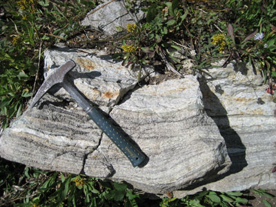
Figure 2. Gneiss with bands of white feldspar and quartz, black biotite, and pale
green diopside
(N40°36.739', W115°22.539').
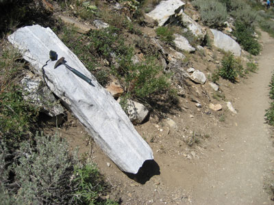
Figure 3. Boulder of granite and pegmatite, both of which are foliated – a term
to describe the alignment of mineral grains, most easily seen in the black biotite
crystals (N 40°36.710', W115°22.533').
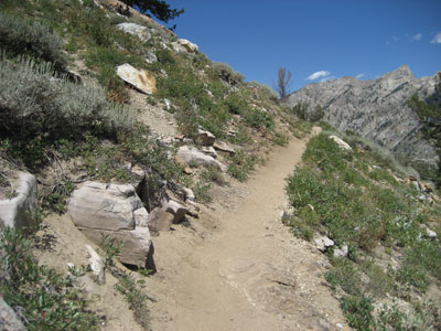
Figure 4a. Marble along the trail between the second and third switchbacks (N40°36.894',
W115°22.563').
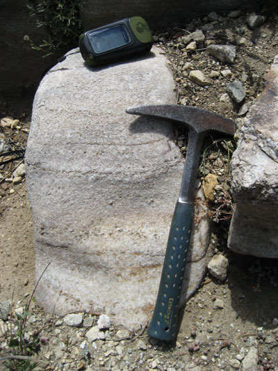
Figure 4b. Close-up view of marble.
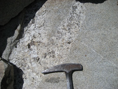
Figure 5. Pegmatite vein with quartz, orthoclase, biotite, and garnet cutting a
non-foliated granite, at the sixth switchback (N40°37.015', W115°22.648').
Deformation and mountain building continue today, but now in an extensional environment in which
the mountains are being uplifted relative to the valley northwest of the Ruby Mountains. This uplift
occurs along a Quaternary (less than 1.8 million years old) fault.
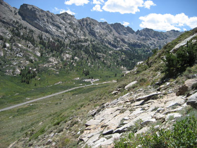
Figure 6a. Second switchback (N40°36.698', W115°22.542'), looking south, back
toward the parking lot.
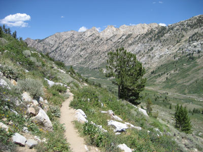
Figure 6b. Second switchback, looking north, down Lamoille Canyon.
The mountains were sculpted by glaciers during the Pleistocene Epoch (from 1.8 million to 10,000
years ago). Although little permanent ice remains now in the Ruby Mountains, only in high areas
protected from the sun, there is abundant evidence for large Pleistocene glaciers. Glacial features
include:
• Smooth canyon walls polished by rocks trapped in the ice as it flowed down the canyons)
• Moraines (mounds and ridges of unsorted blocks of boulders, cobbles, sand, and silt
transported and left behind by the glaciers)
• Classic glacial topographic features:
      • U shapes of Lamoille Canyon and several tributary valleys (carved by the glaciers as the slowly flowed down
      the valleys)
      • Cirques (high walls at the heads of the glaciers)
      • Arêtes (ridges carved by the glaciers with cirques on either side)
      • Horns (sharp peaks left behind where three or more glaciers cut into the mountain),
      and
      • Cirque lakes (for example, Island Lake)
      • Lateral moraines from tributary glaciers are well exposed in a few places; they appear to have partially
      blocked the main Lamoille Canyon at the Right Fork of Lamoille Creek (east of the overlook down onto Camp
      Lamoille) and at Thomas Canyon (also on the east side of the tributary canyon)
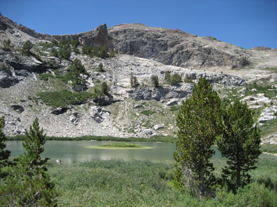
Figure 7a. Island Lake (N40°36.934', W115°22.791'), a lake that occupies the
head of the glacial valley (cirque). The glacier that occurred here during the
Pleistocene Epoch was a hanging glacier – hanging down to join the glacier in
Lamoille Canyon.
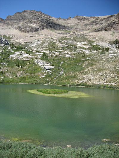
Figure 7b. Another view of Island Lake (N40°36.871', W115°22.809').
Minerals that can easily be identified in rocks of Lamoille Canyon include:
• Orthoclase and microcline (two types of feldspar), both of which are solid solutions of dominantly KAl2Si3O8 and NaAlSi308, found in the granite, pegmatite, and gneiss – clear to milky white, with cleavage.
• Plagioclase (another type of feldspar), a solid solution of dominantly
NaAlSi3 and CaAl2Si2O8, found in the granite and gneiss – clear to milky white, with cleavage and tiny lamellae from crystal twins.
• Quartz, SiO2, found in the granite, pegmatite and gneiss – lacking cleavage, breaks along curved fractures like glass.
• Biotite (a type of mica), a solid solution of dominantly KFe3AlSi3O10(OH,F)2 and KMg3AlSi3O10(OH,F)2, found in gneiss, pegmatite, and granite – generally black flakes, although when chemically weathered, the flakes are commonly golden brown.
• Muscovite (a type of mica), KFe3AlSi3O10(OH,F)2 found in pegmatite and granite – white or clear, transparent flakes.
• Hornblende (a type of amphibole), a complex solid solution described chemically as (Ca,Na,K)2-3(Mg,Fe,Mn)3-4(Al,Fe)2-1(Si,Al)8O22(O,OH,F)2found in granite – generally black prisms with two directions of cleavage at 60° and 120°.
• Actinolite (another type of amphibole), a solid solution described chemically as Ca2(Mg,Fe)5Si8O22(O,OH,F)2 found in gneiss – green prisms with two directions of cleavage at 60° and 120°.
• Diopside (a type of pyroxene), a solid solution described chemically as Ca(Mg,Fe)Si2O6 found in gneiss – green prisms with two directions of cleavage at 90°.
• Garnet, a complex solid solution described chemically as (Fe,Mg,Ca)3(Al,FE)2Si3O12 or as a mixture of almandine, Fe3Al2Si3O12; pyrope, Mg3Al2Si3O12; andradite, Ca3Fe2Si3O12; grossular, Ca3Al2Si3O12; and spessartine, Mn3Al2Si3O12 – glassy, red crystals, generally less than 2 millimeters in diameter. The “Ruby” Mountains get their name from these garnet crystals; as far as we know, there are no rubies here.
• Calcite, CaCO3 – generally white, found primarily in the marble but also in some gneiss and as thin white coating on some rocks; if crystals are large enough, it breaks into rhombohedra; softer than quartz and other common
minerals found here.
• Ilmenite,, FeTiO3, generally in a solid solution with hematite, Fe2O3, found in the granite and gneiss as metallic gray grains generally less than 1 millimeter in length.
• Hematite,, Fe2O3 - red coating on some rock and fracture surfaces.
• Vesuvianite (also known as idocrase),a complex solid solution described chemically as Ca10(Mg,Fe)2Al4(SiO4)5(Si2O7)2(OH)4, found in gneiss as light greenish- brown prisms with vertical striations.
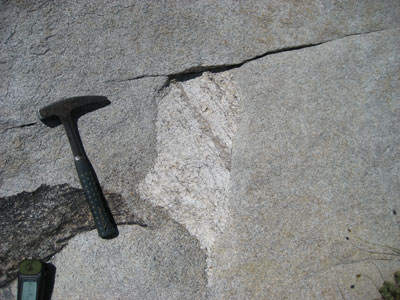
Figure 8. Inclusion (xenolith) of foliated granite with a quartz vein inside a younger,
non-foliated granite (N40°37.061', W115°22.707').
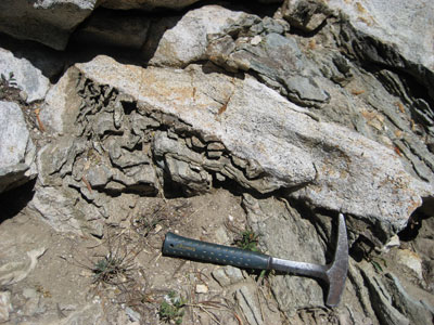
Figure 9. Dike of granite intruded into folded gneiss (N40°36.975', W115°22.781').
On weathered surfaces, layers of resistant minerals in the gneiss stick out; chemically
or physically less resistant minerals have been eroded from layers between more
resistant layers.
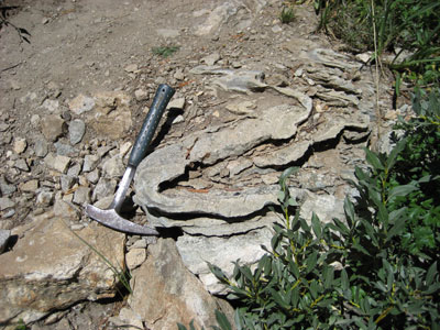
Figure 10a. Folded gneiss (with S shapes in individual layers in the gneiss (N40°36.963',
W115°22.785'), on the north side of the creek.
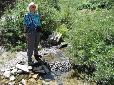
Figure 11b. Folded gneiss in the bed of the creek.
Rocks that can easily be found along the hike include the following:
• Granite – generally light gray with white feldspar (both plagioclase and orthoclase or
microcline); clear, gray, or milky white quartz; and black biotite, hornblende, ilmenite; and
occasionally red garnet (crystals generally only a few millimeters in diameter).
• Pegmatite – generally white or cream-colored with white or cream-colored feldspar (both
plagioclase and orthoclase or microcline), clear or milky white quartz, black biotite, clear
muscovite, and occasionally red garnet (crystals commonly several centimeters in diameter,
although garnets are rarely larger than 3 millimeters.
• Gneiss – rock with distinctive light-and-dark banding, sometimes with individual bands
complexly folded into S, V, and U shapes. Common minerals are white feldspar and quartz,
black biotite, and green diopside and actinolite.
• Marble – rock composed almost entirely of coarse (grains generally 2 to 5 millimeters in
diameter) calcite. Before metamorphism, the rock was probably a nearly pure limestone
(also composed of calcite, but without the big crystals). Impure limestones (ones with
variable amounts of calcite and aluminosilicate clays and quartz) and dolomites (sedimentary
rocks composed mostly of the mineral dolomite, CaMg(CO3)2), were metamorphosed to
gneiss with variable amounts of calcium-aluminosilicate minerals (diopside, actinolite,
vesuvianite).
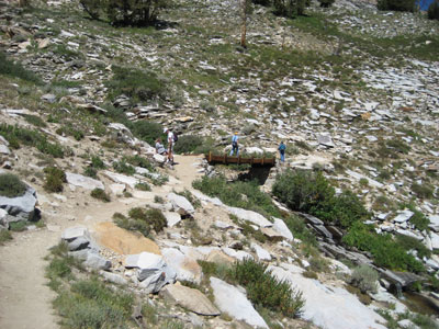
Figure 12a. Wooden bridge (N40°36.997', W115°22.617') viewed from below.
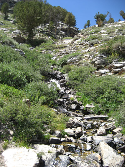
Figure 12b. View up the creek from the wooden bridge.
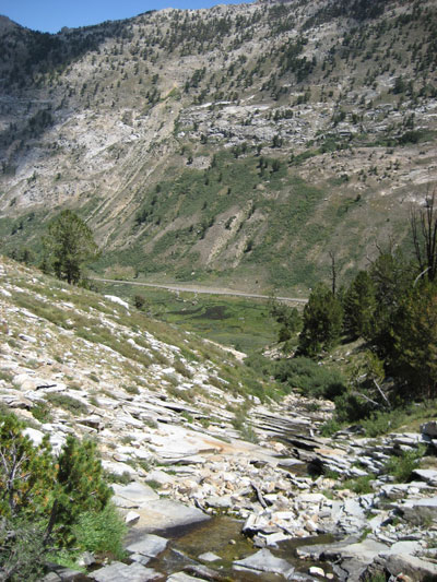
Figure 12c. View down the creek from the wooden bridge.
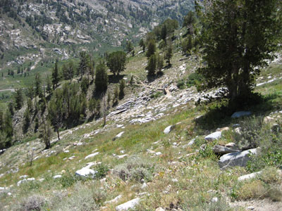
Figure 12d. Wooden bridge viewed from above.
Question to be answered to log the Earthcache
In which general direction (N, S, E, W) does the stream that drains the Island Lake flow on its way to Lamoille Creek?

Figure 13. First switchback (N40°36.742', 15°22.516'). The U shape of Lamoille
Canyon is easy to see along the switchbacks.
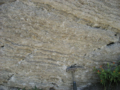
Figure 14. Banded gneiss (N40°36.939', W115°22.764').
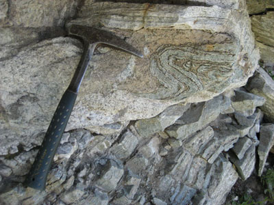
Figure 15. Banded gneiss (N40°36.939', W115°22.764').
References:
Hodges, K.V., Snoke, A.W., and Hurlow, H.A., 1992, Thermal evolution of a portion of the Sevier hinterland: The northern Ruby Mountains-East Humboldt Range and Wood Hills, northeastern Nevada: Tectonics, v. 11, p. 154-164.
Howard, K.A., 1987, Lamoille Canyon nappe in the Ruby Mountains metamorphic core complex, Nevada: in Hill, M.L, ed, Cordilleran Section: Geological Society of America Centennial Field Guide, v. 1, p. 95-100.
Howard, K.A., 2000, Geologic map of the Lamoille Canyon Quadrangle, Elko County, Nevada: Nevada Bureau of Mines and Geology Map 125, 1:24,000 scale.
SPECIAL NOTES ABOUT CONDITIONS AT THIS SITE
The elevation climb is from approximately 8770 feet (2673 meters) above sea level at the parking lot to 9680 feet (2950 meters) at the lake. It is advisable to wear sturdy hiking boots and gloves if you venture off the trails.
CAUTION IN USING GPS UNITS AND TOPOGRAPHIC MAPS
Note that GPS coordinates are relative to a particular datum used to describe the nearly spherical shape of the Earth’s surface. Most topographic maps published by the U.S. Geological Survey use the North American Datum of 1927 (NAD 27), but most GPS units are set for either the North American Datum of 1983 (NAD 83) or the World Geodetic System of 1984 (WGS 84). NAD 83 and WGS 84 give nearly identical locations with hand-held GPS instruments, but NAD 27 can be off considerably. In this part of Nevada, there is little change in latitude between the 1927 and 1983 data, but for longitude the datum of 1983 is shifted relative to the datum of 1927, such that, if you use your GPS unit to measure a location using WGS 84, the point will plot on the U.S. Geological Survey topographic map approximately 100 meters farther east than its true location on the map. If your GPS unit is set to NAD 27, you need to look for the WGS 84 waypoint approximately 100 meters farther east from your location.
BASIC VISITOR-USE AND PUBLIC SAFETY INFORMATION FOR PUBLIC LANDS IN NEVADA:
All visitors need to plan ahead and prepare for outings in Nevada’s public lands by:
• Knowing the regulations and special concerns for the area you are planning to visit (obeying
laws that prohibit collection or destruction of artifacts)
• Carrying a map and a GPS unit and/or compass (Maps are available for purchase at all BLM
offices and from the Nevada Bureau of Mines and Geology, www.nbmg.unr.edu.)
• Staying on existing roads and trails
• Staying away from all mine shafts and adits
• Planning for extreme weather, hazards, and emergencies
• Carrying a full-size spare tire, extra food, water, and warm clothing
• Being aware that cell phones DO NOT usually work in the rural areas away from the major
highways
• Leaving your travel plans with a responsible party, including the date and time of your
return
• Linking to “Tread Lightly and Leave No Trace” websites (www.treadlightly.org and
www.lnt.org).
The core of the Ruby Mountains is part of the Humboldt-Toiyabe National Forest. For more information, please contact the National Forest Service at 775-882-2766.
Please see www.nbmg.unr.edu/ScienceEducation/EarthCaches/EarthCaches.html for more information about other Nevada
EarthCache and GeoCache sites of geologic interest. Thank you.
Contributed by Jonathan G. Price, Elisabeth M. Price, and Daphne D. LaPointe, with photographs taken on August 9, 2007.
 Home
Home