
Volcanic and Sedimentary Rocks of the Monte Cristo Range
Esmeralda County, Nevada
GPS Coordinates: N38°03.315', W117°47.310' (WGS 84)
LOCATION: Along a dirt road (a high-clearance vehicle is advisable), approximately 3 miles north
of Blair Junction, where U.S. Highway 95 (also U.S. Highway 6) and Nevada Highway 265
intersect, 35 miles west of Tonopah, 6 miles east of Coaldale Junction, and 21 miles north of
Silver Peak.
WAYPOINTS: N38°01.128', W117°46.592' : on the north side of the highway at Blair Junction,
where U.S. Highway 95 (also U.S. Highway 6) and Nevada Highway 265 intersect, 35 miles west
of Tonopah, 6 miles east of Coaldale Junction, and 21 miles north of Silver Peak; drive north on
the dirt road. N38°02.261', W117°47.199': where a road comes in from the west; drive north
along the main road. N38°02.752', W117°47.191': where a road comes in from the northwest;
turn left onto this road. A one-mile hike from the EarthCache site, up the western of two canyons in this area, takes you past point N38°02.752', W117°47.191' to a point at N38°02.752', W117°47.191', where you turn to come down the eastern canyon.
GEOLOGY
This starkly beautiful area was part of an active volcano millions of years ago. Today the area is underlain primarily by volcanic and sedimentary rocks that are between about 24 and 11 million years old (part of the Miocene Epoch, Tertiary Period, Cenozoic Era), and there are no active volcanoes nearby. The most abundant rocks are white and pink tuff (rock composed of ash, crystals, rock fragments, and pumice violently erupted from a volcano); gray, green, and brown andesite (lava flows and feeder intrusions to the lava flows); and white, bedded sandstone
composed largely of volcanic debris. Quaternary (less than 1.8 million years old) alluvium – unconsolidated sediments eroded from older rocks – fills stream bottoms and underlies gentle fanshaped slopes leading from the highway up to the bedrock areas. Some older sedimentary rocks (chert, argillite, shale, siltstone, sandstone, and limestone), which were deposited during the Cambrian to Devonian Periods, between about 500 and 350 million years ago, occur approximately one kilometer to the west of this locality and occasionally as rock fragments in the tuffs. Erosion during the last several thousand years has sculpted the tuffs into unusual and picturesque shapes.
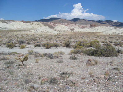
Figure 1. White tuffaceous sediments and tuffs in the foreground, with higher parts
of the Monte Cristo Range in the background (looking north from Blair Junction on U.S.
Highway 95 and 6).
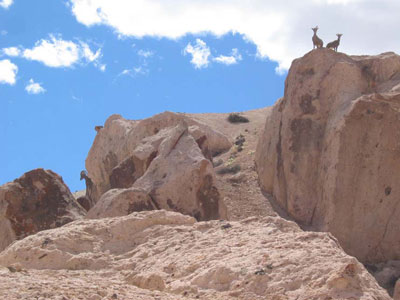
Figure 2. Bighorn sheep standing on tuff (Tcp on the geologic map).
Figure 3. Pinkish white fragments of pumice stand out in pink tuff (Tcp on the
geologic map).
Rocks that can easily be found in this area:
• Rhyolite, volcanic rock occurring as both tuff (a mixture of ash and rock that were violently erupted from a volcano) and lava flow – commonly white (tuffs) and pink (both tuffs and lava flows).
• Dacite, volcanic rock occurring primarily as lava flows – generally dark gray to brown in color.
• Andesite, volcanic rock occurring as both lava flows and dikes (intrusions into older rocks) – commonly black, dark brown, or dark green in color; occasionally in the form of hexagonal, pentagonal, or rectangular columns with dimensions of several tens of centimeters.
• Sandstone, siltstone, and conglomerate; sedimentary rock composed of sand (grains between 0.063 and 2 mm in diameter), silt (grains between 0.004 and 0.063 mm in diameter), and gravel (grains larger than and mixed with sand), respectively, derived primarily from erosion of volcanic rocks (tuffaceous) – generally white (sometimes red where baked by intrusions of andesite) with layers that are several centimeters thick.
• Petrified wood – found in and eroded from the sandstone and siltstone, formed by replacement of wood in the sandstone and siltstone by quartz; can be confused with rhyolite with flow banding.
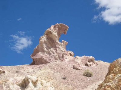
Figure 4. Water (and perhaps wind) has sculpted the tuffs (particularly Tcp on
the geologic map) into unusual shapes.
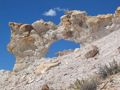
Figure 5. There are a few natural arches in the area.
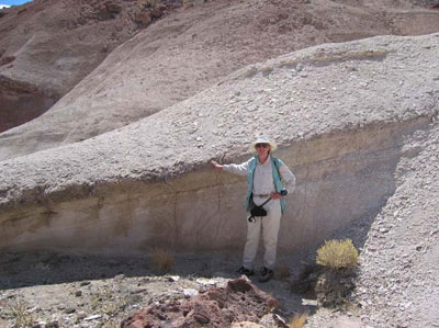
Figure 6. Sedimentary layers, which can be recognized by beds ranging from a few
millimeters to several centimeters thick, occur within both tuffs (Tcp and Tbjt). Some
of the sedimentary layers are particularly rich in smectite, which, when wet, tends to
coat the surface and obliterate the layering in the rock beneath it. Petrified wood is
mostly found in the sedimentary layers.
Minerals that can easily be identified in this area (mostly as crystals a few millimeters in size):
• Sanidine (a type of feldspar), a solid solution of dominantly KAlSi3O8 and NaAlSi308, found mostly in the tuff – clear to milky white, with cleavage.
• Plagioclase (another type of feldspar), a solid solution dominantly NaAlSi3O8 and CaAl2Si2O8, found in the tuff, dacite, and andesite – clear to milky white, with cleavage and tiny lamellae
from crystal twins.
• Quartz, SiO2, and its colorful, compact varieties, agate and chalcedony, abundant in the tuff and dacite – lacking cleavage, breaks along curved fractures like glass.
• Biotite, a solid solution of dominantly KFe3AlSi3O10(OH,F)2 and KMg3AlSi3O10(OH,F)2, found in tuff, dacite, and andesite – generally black flakes.
• Hornblende, a complex solid solution described chemically as (Ca,Na,K)2-3(Mg,Fe,Mn)3-4(Al,Fe)2-1(Si,Al)8O22(O,OH,F)2, found in andesite, dacite, and tuff – generally black prisms with two directions of cleavage at 60° and 120°.
• Clinopyroxene and orthopyroxene, solid solutions of dominantly CaSiO3, MgSiO3, and FeSiO3, found mostly in the andesite – generally black (sometimes dark green) prisms with two directions of cleavage at 90° but also without visible cleavage.
• Magnetite, a solid solution of dominantly Fe3O4 and Fe2TiO4, found in andesite, dacite, and tuff – easily attracted to a magnet, particularly if you put the magnet into the loose material eroded from the volcanic rocks.
• Opal, SiO2·nH2O – generally white; may be bright green in ultraviolet light, because of trace amounts of uranium incorporated in the structure when the mineral precipitated.
• Calcite, CaCO3 – generally white; if crystals are large enough, it breaks into rhombohedra; softer than quartz and other common minerals found here.
• Smectite, a complex solid solution described chemically as (Na,Ca)1-x(Al,Mg)4(Si,Al)8O20(OH)4·8H2O – a clay mineral that expands when wet, coating some of the surfaces of the tuff, sandstone, and siltstone.
• Zircon, ZrSiO4 – small crystals (<1 mm in diameter) in tuffs.
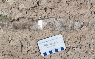
Figure 7. Calcite occurs in veins, sometimes along faults, in the
tuff.
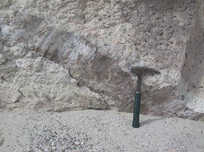
Figure 8. Fault surface (next to the hammer) that is polished and grooved (termed
a slickenside) in tuff. (N38°03.611', W117°47.320')
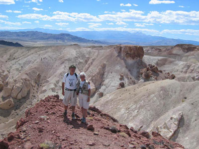
Figure 9. Erosion has carved the canyons and natural sculptures in the area.
Boundary Peak, the highest point in Nevada, is in the center background of
this
photo.
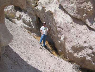
Figure 10. Fault surface (next to the hammer) in tuff. (N38°03.564', W117°47.313')
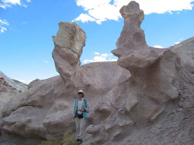
Figure 11. Many of the unusual natural sculptures occur along the edges of the
canyons. They were probably formed primarily by water that flowed down the
canyons during rainstorms.
EVIDENCE OF MOUNTAIN BUILDING
Whereas lava flows and tuffs may have been deposited on the slopes of the volcano or in valleys nearby, the sandstones and other tuffaceous sedimentary rocks were deposited in nearly horizontal layers. Today they are tilted by forces related to mountain building and earthquakes. Earthquakes typically occur along faults, when one large mass of rock slides rapidly against another, commonly leaving striations or scratches in the rock or giving the fault plane a polished surface. Numerous large and small faults can be seen in this area.
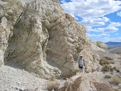
Figure 12. Deformed layers in tuffaceous sandstone (probably formed shortly after
the sediments were deposited, while they were poorly consolidated and wet).
(N38°03.462', W117°47.275')
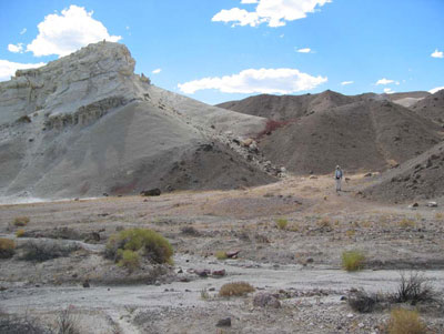
Figure 13. The dark greenish andesite intrusion to the right turned the
normally white tuffaceous sedimentary rocks to the left into a brick-red
colored rock when it intruded. (N38°03.428', W117°47.292')
QUESTIONS
In what direction (N, NE, E, SE, S, SW, W, or NW) do the tuffs, sandstones, and other tuffaceous sedimentary rocks in this area dip? Dip is a vector that describes the orientation of a plane. It is perpendicular to the strike of the plane, which is the intersection of the plane and a hypothetical horizontal surface. The direction of dip is downward along the plane. The angle of dip is the angle from horizontal. A dip of zero degrees is horizontal, and a dip of 90 degrees is vertical. A plane that dips to the north has an east-west strike and gets deeper into the Earth to the north. Do the sandstones dip away from the mountain or toward the mountain?
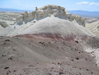
Figure 14. Red (baked) tuffaceous sediments next to andesite dike. This picture
was taken from a point on the right-hand side of Figure 13.
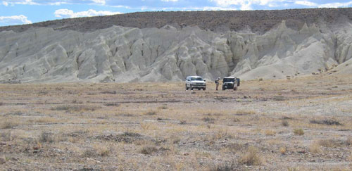
Figure 15. Layering in the tuff and tuffaceous sediments at the EarthCache site.
(N38°03.359', W117°47.234')
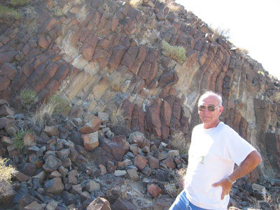
Figure 16. Columnar jointed andesite from higher in the Monte Cristo Range to the
northeast of this locality. Boulders of this rock can be found throughout the area.
References:
Stewart, J.H., Kelleher, P.C., and Zorich, E.A., 1994, Geologic map of the Monte Cristo Range area, Esmeralda and Mineral Counties, Nevada: U.S. Geological Survey Miscellaneous Field Studies Map MF-2260, 1:62,500 scale, with text, 15 p.
Albers, J.P., and Stewart, J.H., 1972, Geology and mineral deposits of Esmeralda County, Nevada: Nevada Bureau of Mines and Geology Bulletin 78, 80 p., with maps at 1:250,000 scale.
SPECIAL NOTES ABOUT ACCESS AT THIS SITE
Four-wheel drive is advisable because of loose sand in the streambeds that the road crosses after the third waypoint. You can normally make it to the third waypoint without four-wheel drive.
Hiking up and down the canyons here involves some steep, rocky and loose ground. Wear sturdy hiking boots. It is also advisable to wear gloves.
CAUTION IN USING GPS UNITS AND TOPOGRAPHIC MAPS
Note that GPS coordinates are relative to a particular datum used to describe the nearly spherical shape of the Earth’s surface. Most topographic maps published by the U.S. Geological Survey use the North American Datum of 1927 (NAD 27), but most GPS units are set for either the North American Datum of 1983 (NAD 83) or the World Geodetic System of 1984 (WGS 84). NAD 83 and WGS 84 give nearly identical locations with hand-held GPS instruments, but NAD 27 can be off considerably. In this part of Nevada, there is little change in latitude between the 1927 and 1983 data, but for longitude the datum of 1983 is shifted relative to the datum of 1927, such that, if you use your GPS unit to measure a location using WGS 84, the point will plot on the U.S. Geological Survey topographic map approximately 100 meters farther east than its true location on the map. If your GPS unit is set to NAD 27, you need to look for the WGS 84 waypoint approximately 100 meters farther east from your location.
BASIC VISITOR-USE AND PUBLIC SAFETY INFORMATION FOR PUBLIC LANDS IN NEVADA:
All visitors need to plan ahead and prepare for outings in Nevada’s public lands by:
• Knowing the regulations and special concerns for the area you are planning to visit (obeying
laws that prohibit collection or destruction of artifacts)
• Carrying a map and a GPS unit and/or compass (Maps are available for purchase at all BLM
offices and from the Nevada Bureau of Mines and Geology, www.nbmg.unr.edu.)
• Staying on existing roads and trails
• Staying away from all mine shafts and adits
• Planning for extreme weather, hazards, and emergencies
• Carrying a full-size spare tire, extra food, water, and warm clothing
• Being aware that cell phones DO NOT usually work in the rural areas away from the major
highways
• Leaving your travel plans with a responsible party, including the date and time of your
return
• Linking to “Tread Lightly and Leave No Trace” websites (www.treadlightly.org and
www.lnt.org).
Please see www.nbmg.unr.edu/ScienceEducation/EarthCaches/EarthCaches.html for more information about other Nevada
EarthCache and GeoCache sites of geologic interest. Thank you.
Contributed by J.G. Price and E.M. Price, cartography by E.C. Crouse.
 Home
Home