
Science of the Comstock - Earth Science
Home | Tour | Physics | Chemistry | Earth Science | Environment | Scams | Lesson Plans
Earth Science Topics:
Introduction | Mapping | Local Geology | Regional Geology
Regional Geology
Introduction
The regional geology that surrounds the Comstock is influenced by basin-and-range-style and horst-and-graben faulting in a complex regional setting of many different rock ages and formations. These formations are dominated by both sedimentary and volcanic origins. Extensive deformation of the rocks and formations in the region is testiment to the dynamic nature to which the area has been exposed because of being at the fringe of the continent over the eons.
The Great Basin Geographical Province
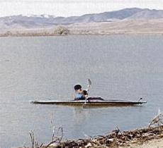
The Comstock Lode lies within the Great Basin geographical province. The Great Basin is a large region that takes in portions of six states and is centered on Nevada. In this part of the world, no rivers exit to the ocean. They end within the boundaries of the Great Basin itself. In the west the Truckee River starts at Lake Tahoe and makes its way downward and eastward to Pyramid Lake, its final stop. The Carson River, which drains the Comstock, is located a few tens of miles to the south of the Truckee, has a similar fate, and goes no further than the Carson Sink. On the other side of the Great Basin is the Great Salt Lake. Here many different streams flow from the high mountains that form the eastern boundary of the basin, the Wasatch Mountains, and feed the Great Salt Lake with fresh water. The pattern throughout the Great Basin is the same; all streams and rivers either sink into the ground or evaporate back into the sky. The young boater shown on Lahontan Reservoir of the Carson River in the below image is on water that will not reach the ocean.
Geology of the Great Basin
The reason that the Great Basin exists is largely tied to the geologic character of the region itself. Throughout the Great Basin deep valleys separate large mountain ranges. The boundaries between the valleys and the mountains are denoted by faults. Strands of mountain ranges with adjacent parallel faults and parallel trending valleys define the fabric of the land. This pattern repeats itself over and over throughout the Great Basin and because of this character the region is also called the "Basin and Range" country.
The Sierra Nevada range bounds the Great Basin on the west. It is a very high mountain range. The rest of the basin is generally lower in elevation. Because the Sierra Nevada is so high, it creates a rain shadow effect that imparts desert-like conditions on much of the Great Basin. Within the eastern Sierra Nevada, the Basin and Range begins. The Sierra represents a giant horst as will be described below.
Horst and Graben
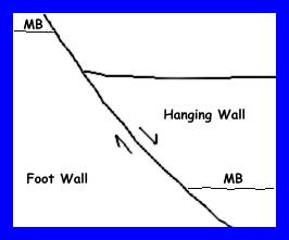
The fabric of the Basin and Range throughout most of the region is such that the mountain ranges are oriented lengthwise north and south. With this in mind, consider that if one crosses Nevada in a straight line from the east to the west, one will "cross the fabric of the land" and repeatedly go from valley to mountain range to valley and so on, as is diagrammed in the above image. Make note that geologists use the term "horst" for the mountain range and "graben" for the valley. This is only true when there are faults separating the two. Shown in the diagram are the bounding faults. These faults have been named "listeric normal faults". These faults have a concave-upward surface because the landscape is being pulled apart by deep-seated tensional forces. These tensional forces are derived from the recent and on-going tectonic characteristics of the region and give it its special character. Many of the fault traces throughout the region show very recent signs of movement, and most of the Great Basin has a very high potential for earthquakes because of these active faults.
Volcanic Action and the Comstock
The Great Basin has had a very complex geologic history that started in Precambrian times. The region has been close to the continent's edge on and off over great periods of time. It has seen numerous, sometimes major tectonic events that at times have added crust and at other times have removed crust. For long periods, great seas covered the land and added sediment. At other times, such as in the Tertiary, great volumes of volcanic rock were added while volcanoes wreaked havoc throughout the region. Within these volcanic rocks along the focus of a normal fault the famously rich Comstock Lode formed.
 Home
Home