
Geothermal Energy:
Home | Published Maps | Interactive Maps | Data | Great Basin Groundwater Geochemical Database | Geothermal Leasing on Federal Lands | Recent Geothermal Projects/Exploration Activity
Great Basin Groundwater Geochemical Database
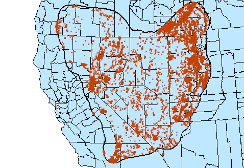
We are upgrading the existing NBMG geochemical database of geothermal samples in Nevada to include all groundwater samples from the Great Basin, hot or cold. Version 3.0 includes all data from the previous geochemical database together with additional National Water Information System (NWIS) data for the entire Great Basin, and NBMG geothermal sampling. Version 3.0 contains data for 47,500 samples from 16,855 sites in 15 data tables. The next version will have a sophisticated GUI to facilitate queries and reports. |
 |
Some of the changes from the previous database include: --Additional samples including the entire Great Basin |
|
Description
This project is a cooperative effort of the Nevada Bureau of Mines and Geology and Great Basin Center for Geothermal Energy. The database contains geochemical information from groundwater samples (primarily springs and wells) in the Great Basin*, from various sources. Samples from both hot and cold temperature groundwaters are included, as cold groundwater can be a useful predictor of geothermal systems (Zehner et. al, 2006). Samples include all known hot water samples in Nevada along with hot and cold groundwater samples from the entire Great Basin from the NWIS data. We are in the process of identifying and entering additional groundwater data from outside Nevada, which will be incorporated into the next Version. Version 2.1 contains 15 tables containing site data, major and minor trace element geochemistry, isotope data, and tables for descriptions, comments, and bibliographic references.
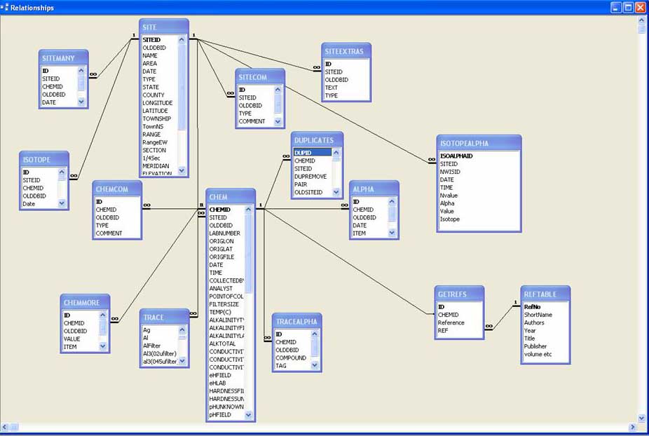
This Access database is arranged in a relational format with one site (defined as a well or single spring orifice) that can have zero to many samples associated with it. There are numerous subtables that contain fields for which there can be multiple ("many") data for either the SITE or CHEM (sample) tables. For example, a single Site can have multiple names, descriptions, site comments, and temperature measurements that are housed in separate subtables of the Site table. To efficiently store the sample data, trace element and isotope information (for which few samples have analyses) are stored in one-to-one relational subtables to the CHEM table. Referential integrity is maintained throughout the database.
All major and trace chemical concentration data are reported in milligrams/liter; to find the reported units in any table of the database, look at the field description in 'design view' for that table. Units were not always reported in the various datasets that comprise the database; if not reported, we looked at concentration histograms and compared them with data having known concentration units. Although this appeared to work well, errors could have been introduced. Similarly, many of the datasets do not report whether the sample was filtered, or if so, the filter size. Unless otherwise noted, we have tried to collect data from samples filtered using a 0.45 μ filter.
We are in the process of checking location information of all samples, and assigning single site information to multiple samples from the same site location. Currently, plotted sample locations around a single site (say a hot spring) resemble a shotgun blast more or less centered on the site, with poorly located samples sometimes kilometers away from their true location. If multiple samples from the same location can be assigned to a specific site, this problem is eliminated, and endeavors such as monitoring the geochemistry of a particular site over time become possible. However, some educated guesswork is necessary to assign sites to samples. For this reason, the original sample ID, source, latitude, and longitude are maintained in the CHEM table.
Sample data with alphanumeric attributes ("<", ">", "Not detected", etc.) have been removed from the CHEM, and TRACE element tables to avoid querying problems**, and moved to separate tables. Thus, major element data with alphanumeric attributes have been placed in the 'ALPHA' table, and trace element data with alphanumerics are in the 'TRACEALPHA' table. If you wish to view or download data having alphanumeric attributes, then a separate query is required.
The complete bibliographic reference to all samples are stored in the REFTABLE, which can be concatenated in a report. This allows for a nearly manuscript-ready bibliography to be downloaded along with the results of any sample query.
Like any large dataset, the Great Basin Groundwater Database contains errors. We have worked to correct poor or nonexistent location data, remove duplicate records, ensure the right units of measurement, and facilitate ease of retrieval. However, we cannot guarantee accuracy.
* Actually an area slightly larger than the Great Basin, as defined by the shapefile "GBOutline.shp."
** This eliminates the possibility of downloading this data unintentionally, thinking it to be unflagged data.
Data Sources
Data for this database have come from various sources, listed below. The original data ID's or keys (where available), along with original location data (latitude and longitude), have been retained in the CHEM table, allowing for error checking.
1.NWIS (National Water Information System)
Major and trace element data for over 42,000 samples from throughout the Great Basin were downloaded in August 2005; isotope and gas data were downloaded in January 2006. Samples from the former GEOTHERM database are included. Since NWIS data is kept on a State by State basis, sample and site data near borders were incomplete and multiple queries were necessary to get all the data. NWIS site and sample data are already in separate tables in a one-to-many relationship, so assigning sites to samples was not necessary. NWIS names typically consist of the latitude/longitude coordinates of the site together with a number or name; we have modified the NWIS name in 'Name' fields to make them more readable. Some NWIS data fields were combined where practical (for example, fields P00056 (flow rate, gallons per day), P00058 (flow rate, gallons per minute), and P00059 (flow rate, instantaneous gallons per minute) were combined and converted to a single field 'Flow rate, liters/minute'. As mentioned above, data with alphanumeric fields ("<", ">", etc.) were removed and placed in separate tables. Some specialty trace or isotope fields with very little data in them (generally if less than 10 of 42,000 samples) were not retained in the database.
2. Mariner Dataset at Nevada-Mod.xls
Data from the 1970's through 1990's, hand entered from hundreds of paper data sheets provided by Robert Mariner of the USGS in Menlo Park, CA. The data set contains over 400 samples including a lot of isotope data, collected predominantly from geothermal sites.
3. Garside Dataset at http://pubs.nbmg.unr.edu/Nevada-low-temp-geotherm-paper-p/of1994-02.htm
Over 450 samples of predominantly geothermal waters collected by Larry Garside of the Nevada Bureau of Mines and Geology for his 1994 Nevada low-temperature geothermal assessment.
4. Geotherm at http://www.nbmg.unr.edu/Geothermal/GEOTHERM.html
GEOTHERM is an obsolete geothermal database built by the USGS in the late 1970's and early 1980's using punch card technology. It does not contain data collected after that time. The +1500 records for Nevada were salvaged by the NBMG and placed in this Excel spreadsheet.
5. Steamboat Springs Data, coming from several sources:
A) Data from the Washoe County Department of Public Works, by M. Widmer and compiled by Colin Goranson: NV-ColinMerged.xls and NV-ColinMerged2.xls. The files contain mostly major element data together with name and some variables such as pH; there is no latitude/longitude data and we are working on this.
B) Additional data from the Washoe County Department of Public Works, by M. Widmer in Steam_chem.xls
6. Dixie Valley Data, in NV.Chem2000a.xls
Geochemical groundwater data by Goff et al., 2002 and Stamates, 2001. No latitude/longitude data is present.
7. Miscellaneous data, hand-entered from various sources, at pubs.zip
8. Geo-Heat Center data
Approximately 850 samples from the much larger Geo-Heat Center Database were entered (e.g., duplicates were removed), primarily from outside of Nevada.
 Home
Home